

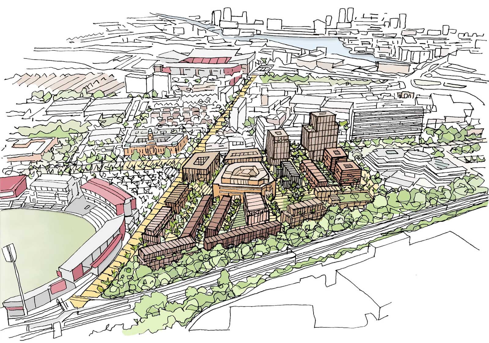
One year on from when Trafford Council announced the proposals for the Trafford Civic Quarter Masterplan, the council have now released details of a proposed masterplan for one part of that scheme for consultation.
More details of the proposals can be found on Trafford Council’s website and you can download the consultation document here.
Previously known as the Campus Quarter, but now described as the Former Kellogg’s Site in the masterplan. Does the name change and change of emphasis have something to do with the poor uptake of student places at UA92?
The university was once pitched as the savour of Stretford by Sean Anstee and Gary Neville, it’s now looking like a bit of a joke at best. Given how badly it appears to be going, I’m particularly glad Gary didn’t get his hands on Turn Moss.
Define
In the define section, the masterplan highlights the key themes that inform the design and strategies, these are:
- Liveable streets and spaces
- Trafford place-making
- Community emphasis
- Diverse and inclusive homes
- Sustainable neighbourhoods
Now, anyone supporting neighbourhood developments that place walking and cycling at their heart will find little to disagree with in those themes. The question is whether the masterplan delivers on those themes. So often, we’re used to seeing the right words, only to be let down by the actual proposals.
Response
The masterplan then goes on to lay out the main design aspects, these are:
- Appropriate building heights
- UA92
- Manage the car
- Apartments
- Arrival
- Townhouses and mansion blocks
- Generous open space provision
- School
Again, many of these aspects are things you’d typically expect in a masterplan, but it’s worth calling some out.
Appropriate building heights
Something of a touchy subject in Manchester now, or as some are calling it, Manchatton. We do seem to be in the middle of some kind of arms race to the top right now, when it comes to building heights. One of the key areas of controversy with the revised UA92 masterplan was the heights proposed for the Lacy Street site.
Now, some people will always be against high rise, my views are a little pragmatic. Where it’s appropriate, I don’t have a problem with tall buildings. What do I mean by appropriate? Well, I think the Deansgate Square development, which includes Manchester’s new tallest building, is appropriate for its location.
An example of a development I don’t think is appropriate is St Michael’s, a huge building planned for the site of the old Bootle Street police station and Manchester Reform Synagogue. Being a stone’s throw from the town hall, the height and design of this development is completely inappropriate for its setting and surrounding buildings.
Manage the car
The masterplan talks about restricting vehicular movement around the site to promote a pedestrian prioritised safe environment. It also talks about consolidating car parking in a single location on the site, with 230 car spaces.
Seeing a masterplan coming out of Trafford Council talking about restricting vehicular movement is absolutely wonderful. It’s clearly something we’d have never seen from the last executive, though it’s still something of a surprise from the current executive.
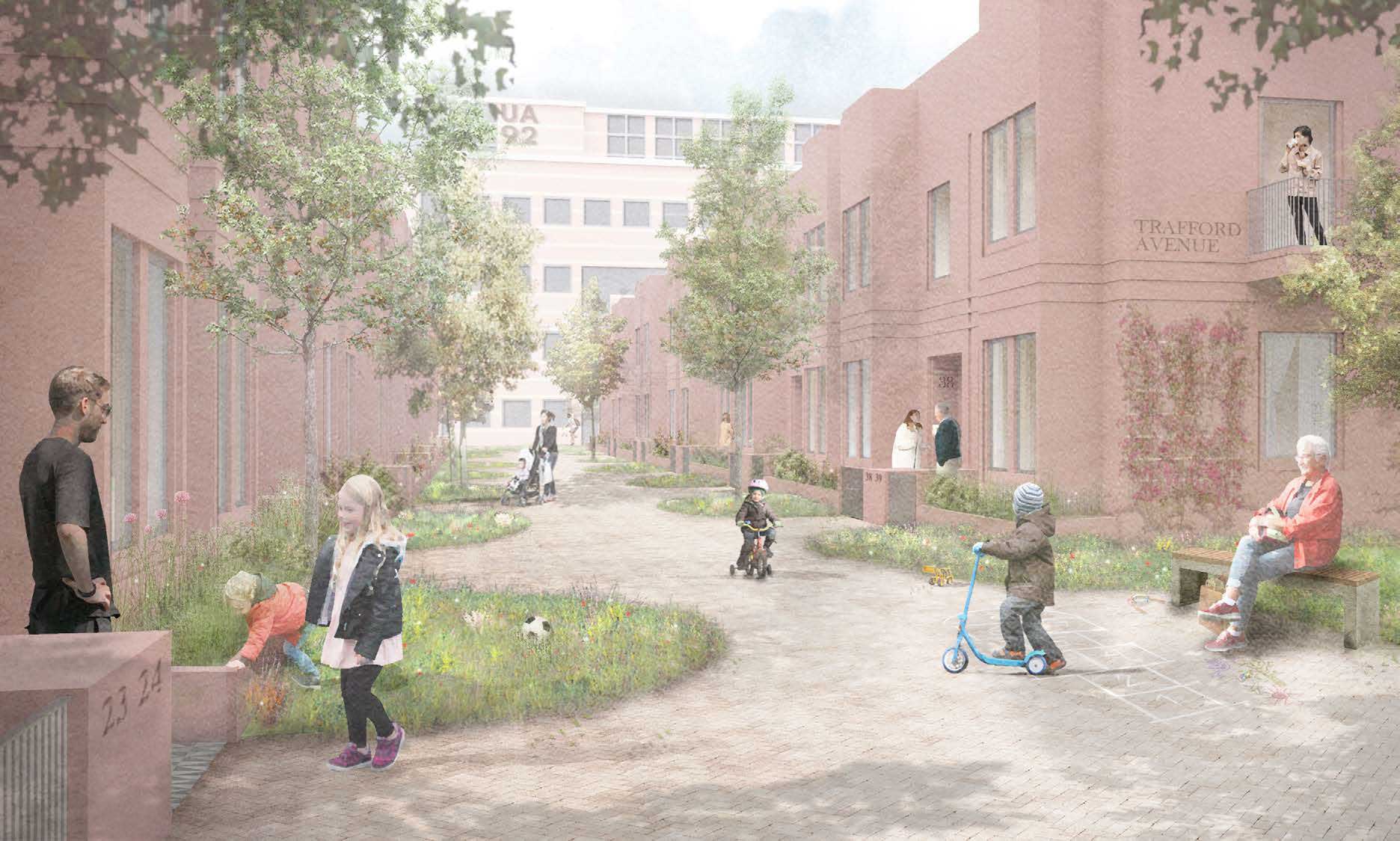
Restricting vehicles from this development sets it apart from pretty much every other scheme we’ve seen in Greater Manchester in recent times. Just go and have a look at any recently completed development in the area and you’ll see streets dominated by motor vehicles and overrun with pavement parking.
A car-free environment like what’s proposed would create space for people to mix and children to play in a safe environment. Of course, I fully support it.
I do question the number of car parking spaces though, which seems excessive. While I appreciate some provision for car parking is going to be needed, I believe the numbers should be lower to encourage people to choose other more sustainable forms of transport.
Generous open space provision
The proposals talk about the equivalent of approximately 2 football pitches worth of publicly accessible open space across the scheme, plus residents garden space and green tree planted streets.
Initial impressions of 2 football pitches sounds like a lot, though it is spread across the scheme. But what’s really key is the removal of motor vehicles and the usable space that creates. Without this, much of this space would be given over to the storage of motor vehicles.
Looking at the plans and taking into consideration the lack of motor vehicles, it should be the case there’s a reasonably decent amount of open space available here.
School
Included in the proposals is the provision of a two-form primary school. To me, this makes it clear the scheme is aimed at creating a diverse community in the area. This sets it apart from many of the developments seen nearby, which only seem to be about attracting buy to let investors and the like.
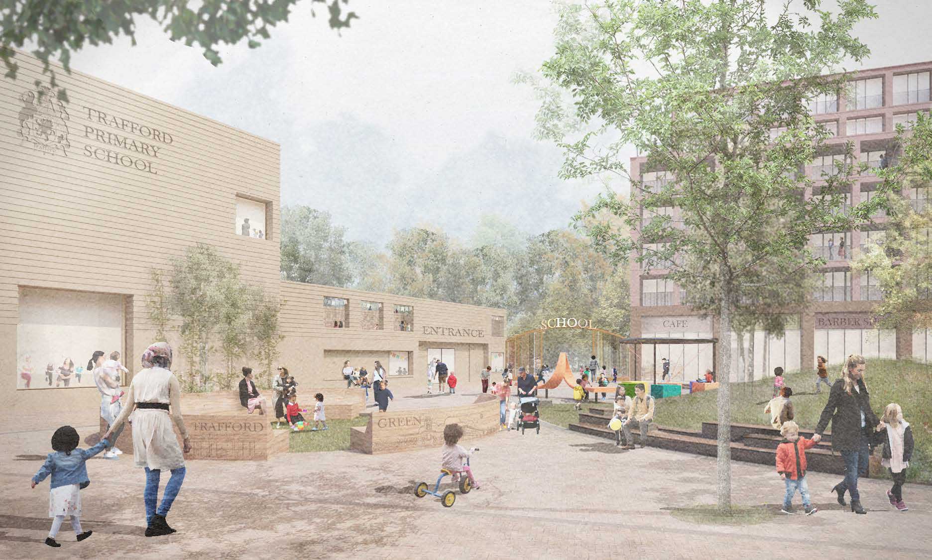
The way the school has been positioned in the overall masterplan sets it apart from other developments too. Access to the school is by foot or bike only as motor vehicles can only go as far as Talbot Road.
This creates a safe and pleasant environment for children and parents walking and cycling to school. It also makes them more attractive options for getting to school than taking the car.
Car dominated and polluted environments around our schools is actively discouraging people from walking and cycling to school. Pavement parking and dangerous driving also mean that parents are increasing worried about their kids making their own way to and from school, choosing to drive them instead and adding to the problem.
Creating a safe, traffic-free environment like this is a bold step in the right direction and something that should adopted around existing schools.
Design
In the design section, the proposals go on to describe the key areas in the design and their usage, these are:
- Neighbourhood central space
- Trafford gateway
- Talbot Road and square
- Brian Statham Way
- UA92 Campus Square
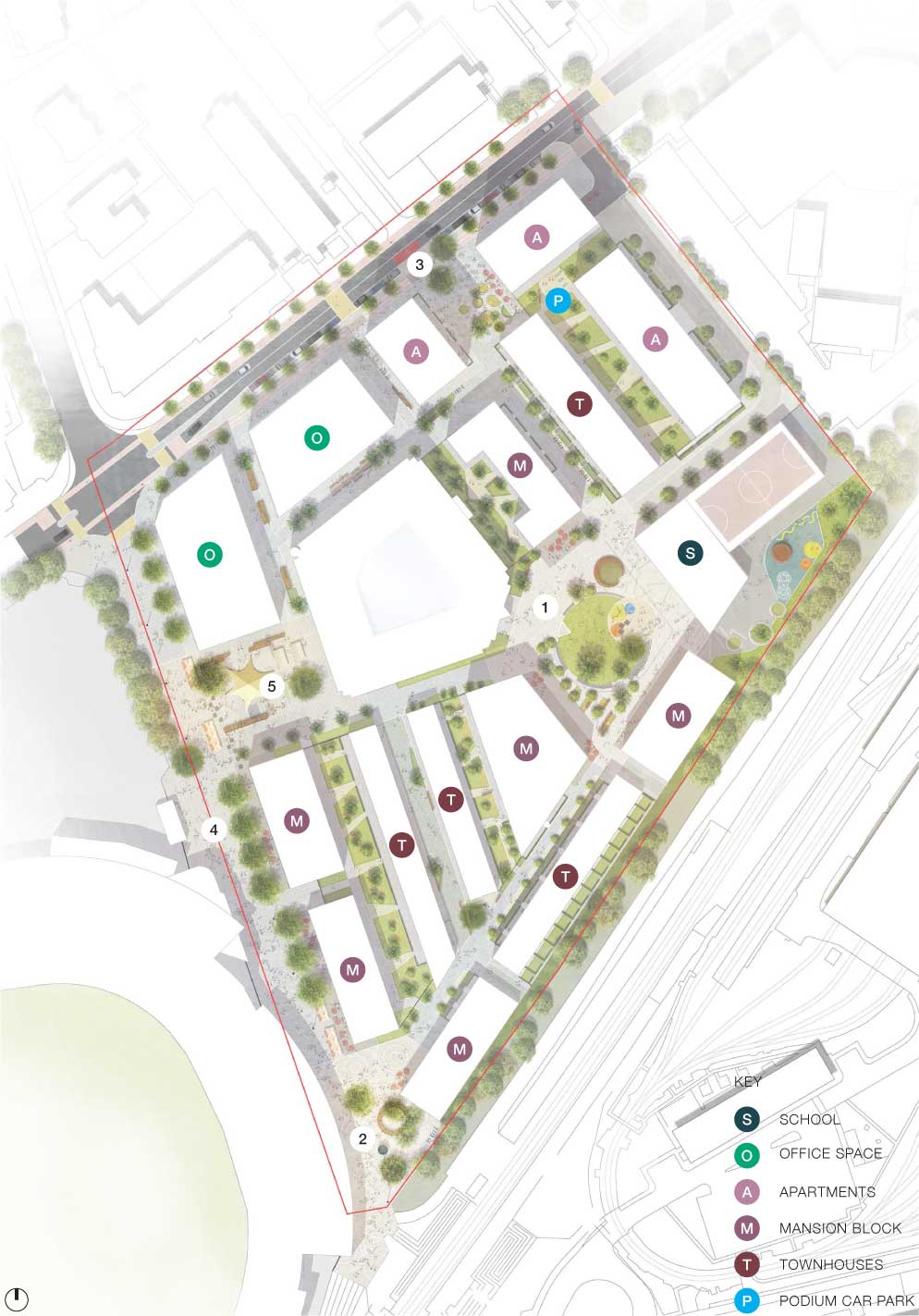
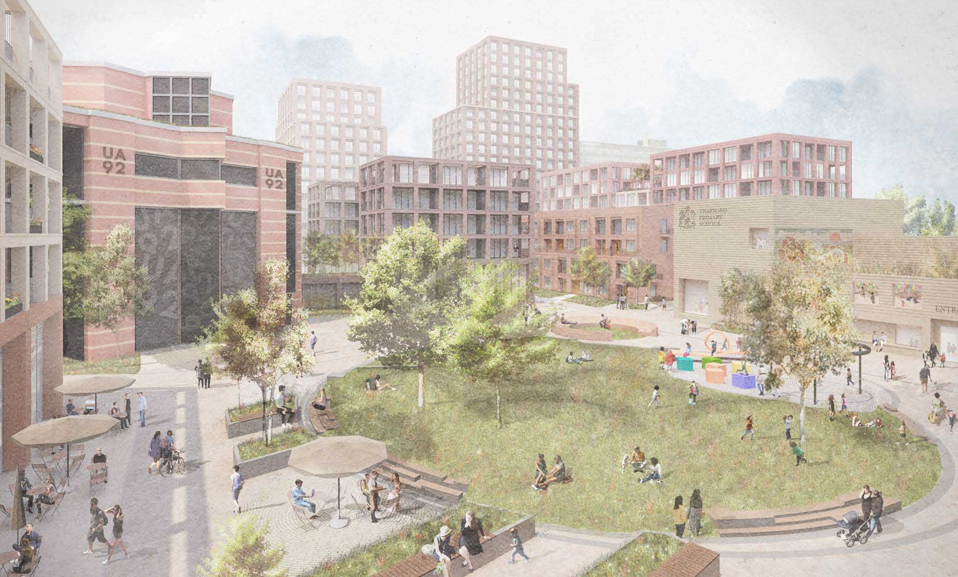
1. Neighbourhood central space
This is the open space that lies between the two educational buildings, UA92 and the new primary school. This looks to provide a focus for the area and from what can be determined from the visualisations, looks like it could be a pleasant space people want to spend time in.
2. Trafford gateway
This is the area immediately around the Old Trafford tram stop at the end of Brian Statham Way. It’s currently a bit of a non space, so plans to create an entrance into Trafford seem reasonable.
3. Talbot Road and square
The consultation document talks about “a long-term ambition from Trafford Council to downgrade Talbot Road to vehicular movement and enhance the pedestrian and cycle experience”.
The recent introduction of the Stretford Cycleway has been a massive improvement to cycling in Stretford, even if does still need connecting properly to the city centre. Though further enhancements and removal of through traffic would be welcome as long as safe protected cycling provision is maintained.
The proposals include a small residential pocket park and on-street parking for school drop-offs. As much as I’d like to see no on-street parking, the reality is if it’s not included here, then people will stop find other places to stop, usually blocking cycleways and footways. So, I guess it’s needed.
4. Brian Statham Way
In the proposals, it says that Brian Statham Way will be closed to free movement of traffic and become a pedestrian prioritised street. I’m not 100% sure what that wording means, though I’m guessing there will still be some access for motor vehicles, but it will be restricted.
It also talks about the ambition to create a ceremonial processional route through here to Manchester United’s stadium as part of making it a more welcoming environment for visitors.
All of this makes sense to me. Brian Statham Way isn’t used much, so turning this into a more welcoming space for visitors while creating an open, attractive space for locals is a good idea.
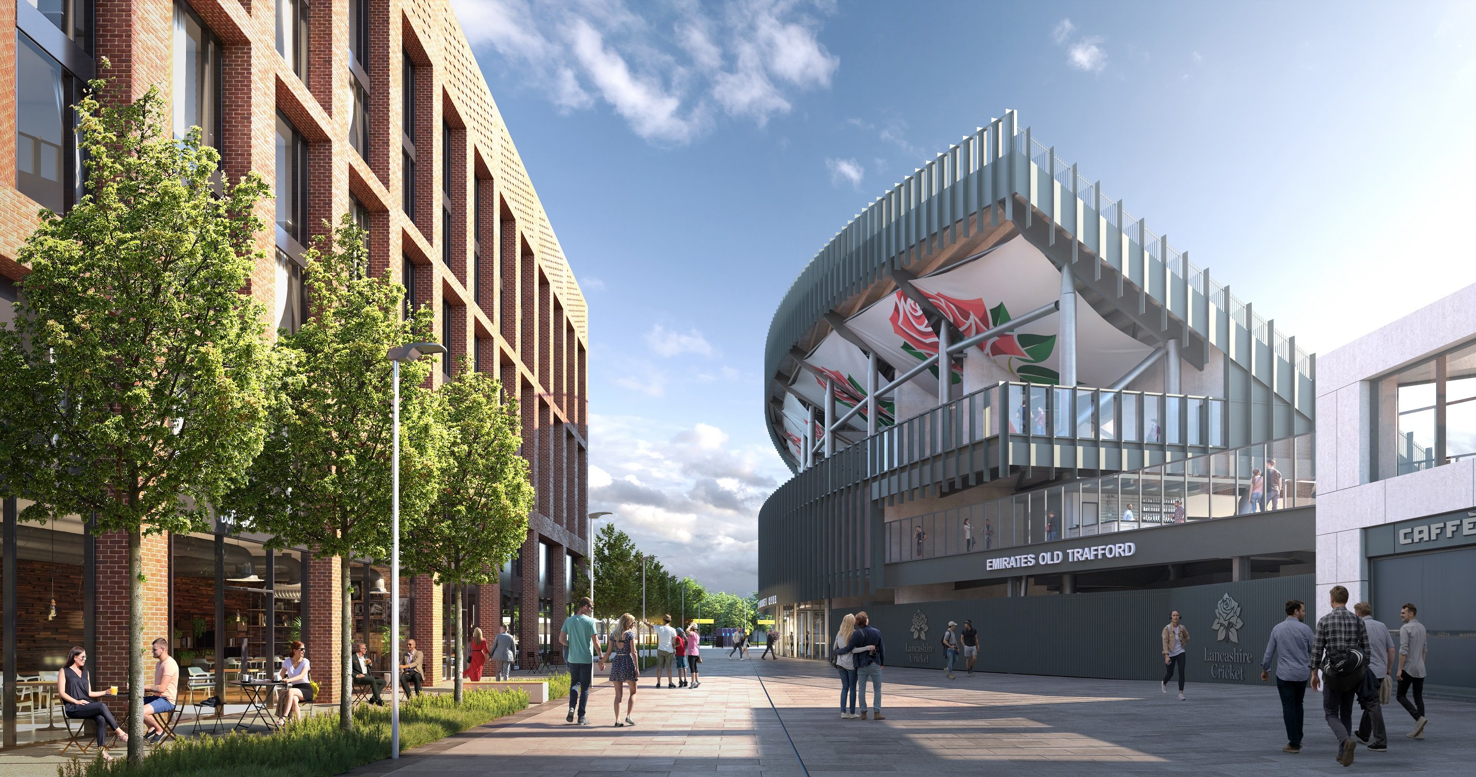
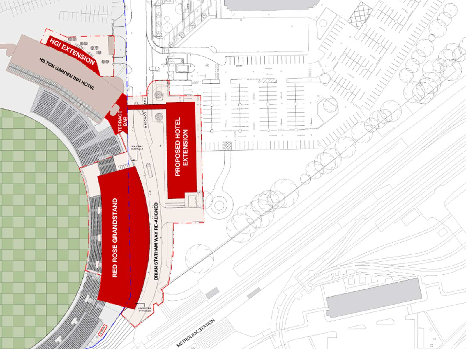
The proposed extension to the Hilton Garden Inn and pedestrian bridge across Brian Statham Way from the LCCC stadium isn’t mentioned in the masterplan. Though it can be found in the planning application 99105/FUL/19, submitted last month and corresponds with one of the mansion blocks in the masterplan.
The LCCC application is separate to this masterplan, though I’m not sure why it wasn’t included anyway, given it was submitted to planning before the masterplan was published.
5. UA92 Campus Square
The UA92 Campus Square is located between UA92 and the new primary school. The plan here is to create what the consultation describes as “generously sized square will allow university life to take ownership of the space”. The square will be surrounded by retail, food and drink units, which I’d imagine would probably see more usage on match days than from UA92 students.
Stretford has been a bit lacking in decent food and drink venues for many years now, with the obvious exception of the wonderful Sip Club. Recently, we’ve seen the addition of some great new venues, including Head, Stretford Food Hall and The Longford Tap.
While that’s great for the town centre, the north side of Stretford is still a bit lacking. So the creation of a new square with potential for a nighttime economy is good news. With the higher densities of residential accommodation in the immediate vicinity, there should be enough potential customers to support this.
I guess one potential issue is noise and anti-social behaviour relating to the new food and drink venues and the proximity of residential units, particularly on match days. But if managed correctly, it doesn’t have to be a problem.
Vision
The vision section goes on to reiterate the points around creating a neighbourhood for Trafford, the community and to live in, through the creation of the square, school, open spaces and safe pedestrianised streets. In my view, the proposals in the masterplan do deliver on these aims.
The vision set out in the masterplan is bold and refreshing, and are such a surprise coming from Trafford Council. The proposals for delivering this vision all look to be appropriate and well thought through. I just hope this vision is realised without becoming compromised or watered down.
I also hope there’s opportunity to take the thinking that’s gone into this masterplan and apply it to our existing neighbourhoods, in conjunction with the Bee Network. Let’s look at how we can make our neighbourhood streets more than places you drive through or store your car and let’s create safe and pleasant environments around our schools, enabling people to choose active travel over cars.
